|
Places
you can visit related to My Brother Sam is Dead
Redding
Ridge
Park
across the street from the Christ Church and explore where
most of the book takes place.
Off
I-95: take Exit 17. Take Route 136 north for 9 miles,
at the intersection of Route 136 and Route 58; take Route
58 north to Redding Ridge. At the four-way stop make a left
and park on the right side of the road.
Off
the Merritt Parkway: take Exit 42. Take Route 136 north
for 5.2 miles, at the intersection of Route 136 and Route
58; take Route 58 north to Redding Ridge. At the four-way
stop make a left and park on the right side of the road.
From
the West: off I-84, take Exit 5. Take Route 53 south for
3.4 miles, at Route 53 and Route 302 follow Route 302 east
for 1.6 miles. At the intersection of Route 58 and Route 302,
follow Route 58 southeast to Redding Ridge. At the four-way
stop make a right and park on the right side of the road.
How
Redding Ridge relates to My Brother Sam is Dead:
This
is where the Meeker's lived. Be sure to explore the Christ
Church cemetery, you'll be amazed at how many characters from
the book are buried here. Across the street from the Church
looking North are the fields Tim runs across when he attempts
to steal back his Father's Brown Bess from Sam. In front of
the Church (Mr. Beach's church) is a stone memorial that pays
respect to the men and children captured during the 1777 Danbury
Raid.
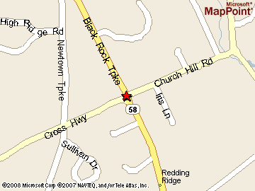
Putnam
Memorial State Park
Hours-
Sunrise to Sunset. Putnam Memorial State Park, 492 Black Rock
Turnpike, Redding, CT 06896
Off
I-95: take Exit 17. Take Route 136 north for 9 miles,
at the intersection of Route 136 and Route 58; take Route
58 north drive 8.8 miles. Putnam Memorial is at the intersection
of Route 107 and Route 58.
Off
the Merritt Parkway: take Exit 42. Take Route 136 north
for 5.2 miles, at the intersection of Route 136 and Route
58; take Route 58 north drive 8.8 miles. Putnam Memorial is
at the intersection of Route 107 and Route 58.
From
the West: off I-84, take Exit 5. Take Route 53 south for
3.4 miles, at Route 53 and Route 302 follow Route 302 east
for 1.6 miles. At the intersection of Route 58 and Route 302,
follow Route 58 south for 2.8 miles. Putnam Memorial is at
the intersection of Route 58 and Route 107.
How
Putnam Park relates to My Brother Sam is Dead:
This
is where Sam Meeker was encamped during the winter of 1778-79.
This is the same camp Tim describes when he attempts to free
Sam from the stockade.
Tim
narrating: "I began to slip down the steep hillside from
stump to boulder
I stopped and I stared. I couldn't see anybody
moving around
I glanced at the guard
he didn't move for several
moments
and I suddenly realized that he was asleep. I took
the bayonet out of my belt and clutched it tight in my hand.
If Sam could killed people, so could I
I stood up and charged
the
guard stirred. I drove my feet faster
"Halt." He shouted.
He swept the musket up, the bayonet pointing straight at me,
twenty feet away
"Sam" I shouted, and "Sam" again as loud
as I could. The guard lunged at me. I lifted the bayonet and
threw it in the air. It flashed in the moonlight, spinning
lazily over and over and fell into the stockade. Then I turned
and began racing as fast as I could across the snow for the
safety of the boulders on the hillside. I had gone only three
paces when the musket went off with a terrific roar
I dashed
onto the slope, and then began staggering upward, zigzagging
from boulder to boulder to keep protection at my back. Behind
me there was shouting and running and the sound of a horse
being wheeled around
I reached the trees at the top of the
ridge and flung myself flat. They'd never get me now
I rolled
over and looked down
I stared into the stockade. There was
no action there, no people moving at all. Lying in the center
of that square of snow, something shiny glistened in the moonlight.
And I knew it had all been a waste. The prisoners weren't
in the stockade anymore."

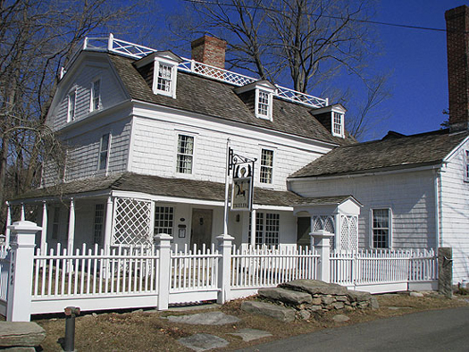
Keeler
Tavern Museum
February - December:
Wednesday, Saturday, Sunday 1 pm to 4 pm. Each tour is approximately
45 minutes and is lead by guides in period costumes. The last
tour begins at 3:30 pm. (The Museum is closed New Year's Day,
Easter Sunday, Independence Day, Thanksgiving and Christmas.)
Admission charge- Adults $5.00 Seniors and Students $3.00
Children under 12 $2.00, Members Free.
132 Main Street
Ridgefield, Connecticut 06877
From I-84 East
or West: Take Exit #3 to Rte. 7 south to Rte #35. Bear
right onto Rte #35 through the Town of Ridgefield. Continue
south on Rte 35 past Rte #102 almost to the Cass Gilbert water
fountain landmark. Keeler Tavern Museum is on the left just
before reaching the fountain.
From New Jersey:
Across the Tappan Zee Bridge to the Saw Mill Parkway north.
Follow Saw Mill Parkway to the end, bearing right to exit
at Katonah/Cross River. Turn right on to Route 35 east. Travel
12 miles, to the stop sign at the Cass Gilbert water fountain
landmark. Turn left, still on Route 35. The Museum is across
from the fountain on the right.
From New York
City:
West Side: Take
the West Side Highway north to the Henry Hudson Parkway (north)
to the Saw Mill Parkway (north.) Follow the Saw Mill Parkway
to the end bearing right to exit at Katonah/Cross River. Turn
right on to Route 35 going east. Travel 12 miles to the stop
sign at the Cass Gilbert water fountain landmark. Turn left,
still on Route 35. The Museum is across from the fountain
on the right.
East Side: FDR
north to 87 north (Major Deegan Expressway) to the New York
State Thruway to 287 east to White Plains (do not get on the
Tappan Zee Bridge.) Take 684 (north) to exit 6 (Cross River/Katonah).
Take a right turn onto on Route 35 east. Travel 12 miles to
the stop sign at the Cass Gilbert water fountain landmark.
Turn left, still on Route 35. The Museum is across from the
fountain on the right. Or: FDR to Third Ave Bridge to Bruckner
Expressway to route 95 east to 287 west (to White Plains)
to 684 (as above).
How
Keeler Tavern relates to My Brother Sam is Dead:
Listed on the National
Register of Historic Places, the Keeler Tavern Museum has
been a farmhouse, tavern, stagecoach stop, post office, hotel
for travelers and a private residence. The Meeker Family Tavern
was very similar and thus Keeler Tavern gives a glimpse at
the way Tim, Sam, Life and Suzanne lived and worked.
Putnam's Cottage
/ Knapp's Tavern Museum
Cottage Tours by
Appointment Only During January, February & March. In Season:
Open Sundays from 1:00-4:00 p.m. and by Appointment Call for
group tour information. 203-869-9697
243 East Putnam
Avenue (U.S. Route 1) Greenwich, CT 06830
From the Merritt
Parkway Take Exit 31 (North Street). Go south 4.2 miles on
North Street to end at Maple Avenue intersection. Turn left
onto Maple and go .3 miles to traffic light at East Putnam
Avenue. Turn left onto East Putnam Avenue and go .2 miles.
Cottage will be on your left.
From the Connecticut
Turnpike (I-95) Take Exit 4 (Indian Field Road). Go north
.7 miles on Indian Field Road, to traffic light at East Putnam
Avenue (U.S. Route 1). Turn left and go west .7 miles (through
3 traffic lights) on East putnam. The Cottage will be on your
right, just beyond the YWCA.
How
Knapp's Tavern relates to My Brother Sam is Dead:
The original house
was probably built for the family of Timothy Knapp in the
first quarter of the 1700s. He and his wife, Martha Weeks,
shared it with their son Isaac Knapp, Sr. and his family,
including his first two children. Later in the century it
was used as a tavern and the meeting place for the local Freemasons.
It is intimately
connected to the Revolutionary war, having housed General
Putnam and hosted General Washington for lunch. The house
has long been associated with General Israel Putnam and his
heroic escape from the British during the Revolutionary War.
General Putnam was Sam Meeker's General in the novel.
Compo Beach
There is a daily
fee for non-residents, contact the town's Park and Recreation
Department at 203-341-5090 for fee schedule.
Compo Beach Road
Westport, Connecticut
From the East:
Take I-95 South to exit 18 to Sherwood Island State Park and
continue 0.16 miles. Take the ramp to US-1/Westport and continue
0.09 miles. Take Sherwood Island Connector/Route 476 North
and continue 0.19 miles. Turn left onto Greens Farms Road
and continue 1.65 miles. Turn left onto Compo Road South and
continue 0.88 miles. Turn slight right onto Compo Beach Road.
From the West:
Take I-95 North. Take the Route 136 exit 17 to Route 33/Westport/Saugatuck
and continue 0.27 miles. Turn slight left onto Saugatuck Avenue/Route
136. Continue to follow Route 136 for 0.37 miles. Turn right
onto Bridge Street/Route 136 and continue 0.50 miles. Turn
right onto Compo Road South for 0.88 miles. Turn slight right
onto Compo Beach Road.
How
Compo Beach relates to My Brother Sam is Dead:
The British landed
on this beach in 1777. From here they marched north through
Redding where they halted for several hours before their attack
on Danbury Connecticut's military depot. Tim describes their
visit in the novel:
Tim narrating:
"I began hearing from a long way away a heavy muttering noise.
It sounded a bit like thunder, but not exactly. It made me
uneasy. I jammed the spade in the ground and went out front
of the tavern to have a look up and down the road. The sound
seemed to be coming from the southwest over behind the church
somewhere
And then I saw Ned, Samuel Smith's Negro, come running
up the road. At the same moment Captain Betts, popped out
of his house next door. Captain Betts was in the Rebel militia.
"What is it, Ned" he shouted. "British Troops, Captain," Ned
shouted. He ran on by."
"The noise grew
louder. I watched, and all at once through the hedgerows I
caught a glimpse of movement and things flashing. In a moment
the vanguard appeared around the bend
On down the road toward
me they came. It was a frightening thing to see. They just
kept coming on and on as if nothing in the world could stop
them."
|